4. Data Format and Source
4.1. Data Format
The
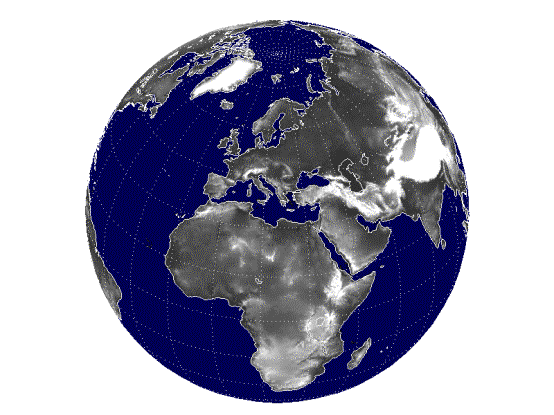
ACE product comprises of a Height dataset and a Source dataset. To Facilitate
Distribution the ACE Height and Source datasets have been divided into 288
smaller pieces, or tiles for each dataset. The area from 90 degrees south
latitude to 90 degrees north latitude and 180 degrees west longitude to 180
degrees east latitude is covered by 288 tiles (for each dataset), with each
tile covering 15 degrees of latitude and 15 degrees of longitude. The tiles
names refer to the latitude and longitude of the lower left (southwest) corner
of the tile. For example, the coordinates of the lower left corner of tile
45S015E.ACE are 45 degrees south latitude and 15 degrees east longitude. The
extension in the tile name refers to the dataset. For example, 45S015E.ACE is
from the height dataset, 45S015E.ACE.SRC is from the source dataset and
45S015E.ACE.QUAL is from the quality dataset.
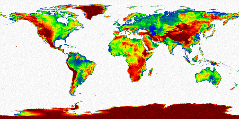
4.1.1 ACE Files (.ACE)
The
DEM is provided as 16-bit little endian (i.e. least significant byte first)
short data in a simple binary raster. There are no header or trailer bytes
imbedded in the image. The data are stored in row major order (all the data for
row 1, followed by all the data for row 2, etc.). Each .ACE file is made up of
1800 rows and 1800 columns and contains one spectral band for the height
values. The value used for masking (i.e. land/sea mask or nodata) is set to
–500.
4.1.2. Source Files (.ACE.SRC)
The
source data is provided as 8-bit little endian (i.e. least significant byte
first) character data in a simple binary raster. There are no header or trailer
bytes imbedded in the image. The data are stored in row major order (all the
data for row 1, followed by all the data for row 2, etc.). Each .ACE.SRC file
is made up of 1800 rows and 1800 columns and contains one spectral band for the
source code values (i.e. from 0 to 21).
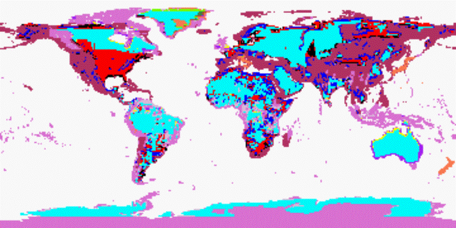
4.1.3. Quality Files (.QUAL)
The
quality data is provided as 8-bit little endian (i.e. least significant byte
first) character data in a simple binary raster. There are no header or trailer
bytes imbedded in the image. The data are stored in row major order (all the
data for row 1, followed by all the data for row 2, etc.). Each .QUAL file is
made up of 1800 rows and 1800 columns and contains one spectral band for the
source code values (i.e. from 0 to 7 and 11 to 17).
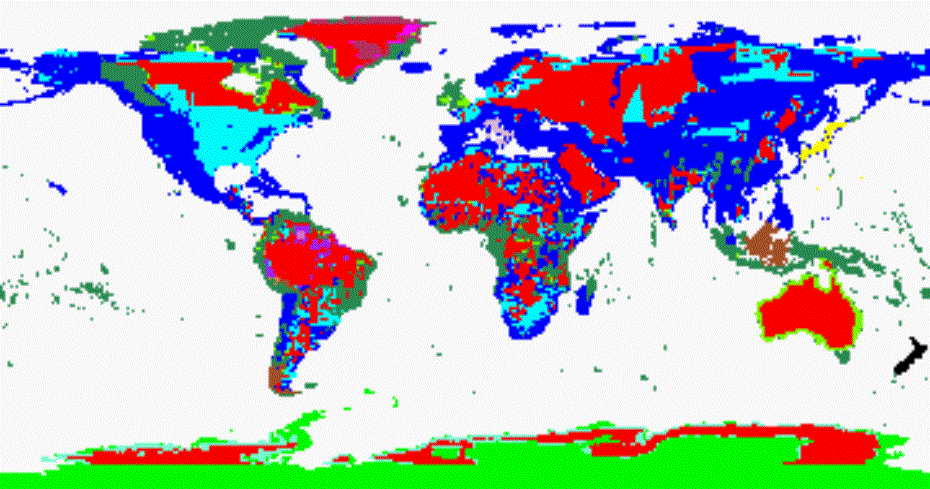
4.2. ACE Data Sources and Source Codes
(i.e. for .ACE.SRC files)
0. Ocean
1. Digital Terrain Elevation Data (DTED),
non-shifted.
2. Digital Terrain Elevation Data (DTED),
shifted using warping technique developed at De Montfort University.
3. Digital Chart of the World (DCW)
developed by Defence Mapping Agency (DMA), converted to 30” grid by U.S.
Geological Survey (USGS), non-shifted.
4. Digital Chart of the World (DCW)
developed by Defence Mapping Agency (DMA), converted to 30” grid by U.S.
Geological Survey (USGS), shifted using warping technique developed at De
Montfort University.
5. DEM of Japan, from Geographical Survey
Institute, Japan (GSI), non-shifted.
6. DEM of Japan, from Geographical Survey
Institute, Japan (GSI), shifted using warping technique developed at De
Montfort University.
7. DEM for Italy, at high resolution from
Servizio Geologico Nazionale (National Geological Survey (Italy))(SGN),
converted to 30” grid by National Geophysical Data Centre (NGDC) (for SGN),
non-shifted.
8. DEM for Italy, at high resolution from
Servizio Geologico Nazionale (National Geological Survey (Italy)) (SGN),
converted to 30” grid by National Geophysical Data Centre (NGDC) (for SGN),
shifted using warping technique developed at De Montfort University.
9. DEM of New Zealand at 500m gridding by
Manaaki Whenua Landcare Research, Ltd., New Zealand (LCR), reprojected to 30”
by U.S. Geological Survey (USGS), non-shifted.
10. DEM of New Zealand at 500m gridding by
Manaaki Whenua Landcare Research, Ltd., New Zealand (LCR), reprojected to 30”
by U.S. Geological Survey (USGS), shifted using warping technique developed at
De Montfort University.
11. DEM of Greenland by Zwally (and
others)/National Snow and Ice Data Centre (NSIDC), converted to 30” by Jet
Propulsion Laboratory (JPL), non-shifted.
12. DEM of Greenland by Zwally (and others)/
National Snow and Ice Data Centre (NSIDC), converted to 30” by Jet Propulsion
Laboratory (JPL), shifted using warping
technique developed at De Montfort University.
13. Army Map Service (AMS) 1:1, 000,
000-scale maps, digitized by Geographical Survey Institute, Japan (GSI),
gridded by U.S. Geological Survey (USGS), non-shifted
14.
Army Map Service (AMS)
1:1, 000, 000-scale maps, digitized by Geographical Survey Institute, Japan
(GSI), gridded by U.S. Geological Survey (USGS), shifted using warping
technique developed at De Montfort University.
15. International Map of the World (IMW)
1:1, 000, 000-scale maps for part of Brazil adapted by Geographical Survey
Institute, Japan (GSI), gridded by U.S. Geological Survey (USGS), non-shifted.
16. International Map of the World (IMW)
1:1, 000, 000-scale maps for part of Brazil adapted by Geographical Survey
Institute, Japan (GSI), gridded by U.S. Geological Survey (USGS), shifted using
warping technique developed at De Montfort University.
17. Peru 1:1, 000, 000-scale maps for part
of Peru by the Ministerio de Guerra of Peru, adapted by Geographical Survey
Institute, Japan (GSI), gridded by U.S. Geological Survey (USGS), non-shifted.
18. Peru 1:1, 000, 000-scale maps for part
of Peru by the Ministerio de Guerra of Peru, adapted by Geographical Survey
Institute, Japan (GSI), gridded by U.S. Geological Survey (USGS), shifted using
warping technique developed at De Montfort University.
19. Scientific Committee on Antarctic
Research (SCAR) Antarctic Digital Database, converted by U.S. Geological Survey
(USGS), repaired by National Geophysical Data Centre (NGDC), non-shifted.
20. Scientific Committee on Antarctic
Research (SCAR) Antarctic Digital Database, converted by U.S. Geological Survey
(USGS), repaired by National Geophysical Data Centre (NGDC), shifted using
warping technique developed at De Montfort University.
21. Altimeter Derived DEM (ACE).
4.3. ACE Data
Quality and Quality Codes (i.e. for .QUAL files)
0. Ocean
1. Validated: Digital Terrain Elevation
Data (DTED), shifted using warping technique developed at De Montfort
University.
2. Validated: Digital Terrain Elevation
Data (DTED), non-shifted.
3. Validated: Altimeter Derived DEM (ACE).
4. Validated:
a)
DEM of
Japan, from Geographical Survey Institute, Japan (GSI), shifted using warping
technique developed at De Montfort University.
b)
DEM for
Italy, at high resolution from Servizio Geologico Nazionale (National
Geological Survey (Italy)) (SGN), converted to 30” grid by National Geophysical
Data Centre (NGDC) (for SGN), shifted using warping technique developed at De
Montfort University.
c)
DEM of New Zealand at 500m gridding by
Manaaki Whenua Landcare Research, Ltd., New Zealand (LCR), reprojected to 30”
by U.S. Geological Survey (USGS), shifted using warping technique developed at
De Montfort University.
d)
DEM of
Greenland by Zwally (and others)/ National Snow and Ice Data Centre (NSIDC),
converted to 30” by Jet Propulsion Laboratory
(JPL), shifted using warping technique developed at De Montfort
University.
e)
Peru 1:1,
000, 000-scale maps for part of Peru by the Ministerio de Guerra of Peru,
adapted by Geographical Survey Institute, Japan (GSI), gridded by U.S.
Geological Survey (USGS), shifted using warping technique developed at De
Montfort University.
5. Validated:
a)
DEM of
Japan, from Geographical Survey Institute, Japan (GSI), non-shifted.
b)
DEM for
Italy, at high resolution from Servizio Geologico Nazionale (National
Geological Survey (Italy))(SGN), converted to 30” grid by National Geophysical
Data Centre (NGDC) (for SGN), non-shifted.
c)
DEM of New
Zealand at 500m gridding by Manaaki Whenua Landcare Research, Ltd., New Zealand
(LCR), reprojected to 30” by U.S. Geological Survey (USGS), non-shifted.
d)
DEM of
Greenland by Zwally (and others)/National Snow and Ice Data Centre (NSIDC),
converted to 30” by Jet Propulsion Laboratory (JPL), non-shifted.
e)
Peru 1:1,
000, 000-scale maps for part of Peru by the Ministerio de Guerra of Peru,
adapted by Geographical Survey Institute, Japan (GSI), gridded by U.S.
Geological Survey (USGS), non-shifted.
6. Validated:
a)
Digital
Chart of the World (DCW) developed by Defence Mapping Agency (DMA), converted
to 30” grid by U.S. Geological Survey (USGS), shifted using warping technique
developed at De Montfort University.
b)
Army Map
Service (AMS) 1:1, 000, 000-scale maps, digitized by Geographical Survey
Institute, Japan (GSI), gridded by U.S. Geological Survey (USGS), shifted using
warping technique developed at De Montfort University.
c)
International
Map of the World (IMW) 1:1, 000, 000-scale maps for part of Brazil adapted by
Geographical Survey Institute, Japan (GSI), gridded by U.S. Geological Survey
(USGS), shifted using warping technique developed at De Montfort University.
d)
Scientific
Committee on Antarctic Research (SCAR) Antarctic Digital Database, converted by
U.S. Geological Survey (USGS), repaired by National Geophysical Data Centre
(NGDC), shifted using warping technique developed at De Montfort University.
7. Validated:
a)
Digital
Chart of the World (DCW) developed by Defence Mapping Agency (DMA), converted
to 30” grid by U.S. Geological Survey (USGS), non-shifted.
b)
Army Map
Service (AMS) 1:1, 000, 000-scale maps, digitized by Geographical Survey
Institute, Japan (GSI), gridded by U.S. Geological Survey (USGS), non-shifted.
c)
International
Map of the World (IMW) 1:1, 000, 000-scale maps for part of Brazil adapted by
Geographical Survey Institute, Japan (GSI), gridded by U.S. Geological Survey
(USGS), non-shifted.
d)
Scientific
Committee on Antarctic Research (SCAR) Antarctic Digital Database, converted by
U.S. Geological Survey (USGS), repaired by National Geophysical Data Centre
(NGDC), non-shifted.
11. Non-validated: Digital Terrain Elevation
Data (DTED), shifted using warping technique developed at De Montfort
University.
12. Non-validated: Digital Terrain Elevation
Data (DTED), non-shifted.
13. Non-validated: Altimeter Derived DEM
(ACE).
14. Non-validated:
a)
DEM of
Japan, from Geographical Survey Institute, Japan (GSI), shifted using warping
technique developed at De Montfort University.
b)
DEM for
Italy, at high resolution from Servizio Geologico Nazionale (National
Geological Survey (Italy)) (SGN), converted to 30” grid by National Geophysical
Data Centre (NGDC) (for SGN), shifted using warping technique developed at De
Montfort University.
c)
DEM of New
Zealand at 500m gridding by Manaaki Whenua Landcare Research, Ltd., New Zealand
(LCR), reprojected to 30” by U.S. Geological Survey (USGS), shifted using
warping technique developed at De Montfort University.
d)
DEM of
Greenland by Zwally (and others)/ National Snow and Ice Data Centre (NSIDC),
converted to 30” by Jet Propulsion Laboratory
(JPL), shifted using warping technique developed at De Montfort
University.
e)
Peru 1:1,
000, 000-scale maps for part of Peru by the Ministerio de Guerra of Peru,
adapted by Geographical Survey Institute, Japan (GSI), gridded by U.S.
Geological Survey (USGS), shifted using warping technique developed at De
Montfort University.
15. Non-validated:
a)
DEM of
Japan, from Geographical Survey Institute, Japan (GSI), non-shifted.
b)
DEM for
Italy, at high resolution from Servizio Geologico Nazionale (National
Geological Survey (Italy))(SGN), converted to 30” grid by National Geophysical
Data Centre (NGDC) (for SGN), non-shifted.
c)
DEM of New
Zealand at 500m gridding by Manaaki Whenua Landcare Research, Ltd., New Zealand
(LCR), reprojected to 30” by U.S. Geological Survey (USGS), non-shifted.
d)
DEM of
Greenland by Zwally (and others)/National Snow and Ice Data Centre (NSIDC),
converted to 30” by Jet Propulsion Laboratory (JPL), non-shifted.
e)
Peru 1:1,
000, 000-scale maps for part of Peru by the Ministerio de Guerra of Peru,
adapted by Geographical Survey Institute, Japan (GSI), gridded by U.S.
Geological Survey (USGS), non-shifted.
16. Non-validated:
a)
Digital
Chart of the World (DCW) developed by Defence Mapping Agency (DMA), converted
to 30” grid by U.S. Geological Survey (USGS), shifted using warping technique
developed at De Montfort University.
b)
Army Map
Service (AMS) 1:1, 000, 000-scale maps, digitized by Geographical Survey
Institute, Japan (GSI), gridded by U.S. Geological Survey (USGS), shifted using
warping technique developed at De Montfort University.
c)
International
Map of the World (IMW) 1:1, 000, 000-scale maps for part of Brazil adapted by
Geographical Survey Institute, Japan (GSI), gridded by U.S. Geological Survey
(USGS), shifted using warping technique developed at De Montfort University.
d)
Scientific
Committee on Antarctic Research (SCAR) Antarctic Digital Database, converted by
U.S. Geological Survey (USGS), repaired by National Geophysical Data Centre
(NGDC), shifted using warping technique developed at De Montfort University.
17. Non-validated:
a)
Digital
Chart of the World (DCW) developed by Defence Mapping Agency (DMA), converted
to 30” grid by U.S. Geological Survey (USGS), non-shifted.
b)
Army Map
Service (AMS) 1:1, 000, 000-scale maps, digitized by Geographical Survey
Institute, Japan (GSI), gridded by U.S. Geological Survey (USGS), non-shifted.
c)
International
Map of the World (IMW) 1:1, 000, 000-scale maps for part of Brazil adapted by
Geographical Survey Institute, Japan (GSI), gridded by U.S. Geological Survey
(USGS), non-shifted.
d)
Scientific
Committee on Antarctic Research (SCAR) Antarctic Digital Database, converted by
U.S. Geological Survey (USGS), repaired by National Geophysical Data Centre
(NGDC), non-shifted.
4.4. Data Distribution
The
two different datasets are distributed as two compressed tar files. The Height
dataset is in the ACEV1_Height.tar.gz
data file and the Source dataset is in the ACEV1_Source.tar.gz
data file and the Quality data is in the
ACEV1_Quality.tar.gz data file. Each of these three .tar.gz files are archives of 288 fifteen degree tiles combined
into one file using the Unix “tar”
command, and the tar file is compressed using GNU “gzip” utility. To use the ACE height data files (.ACE) the
ACE_Height.tar.gz file must be first decompressed and then the individual data
files for each fifteen-degree tile extracted from the tar file. For example the
following Unix command can be used:
gunzip < ACEV1_Height.tar.gz |
tar xvf –
5.
Discussion
The
second release of ACE (ACE Version 1) have addressed the problems of
significant tile offsets over Antarctica by replacing the shifted SCAR
Antarctic Digital Database, converted by USGS, repaired by NGDC (Source code 20
in the ACEb release) with the an Altimeter derived
DEM (ACE, source code 21).
The
second release of ACE (ACE Version 1) includes a full resolution Quality Matrix
have also been included with all the description of all the codes described in
section 4.3 of this documentation. The quality codes in ACE Version 1 range
from 1 to 17. Table 2 in Section 3.1.2, and the list of descriptions for the
quality codes in Section 4.3 of this documentation defines the data quality
codes used in the ACE Version 1 Quality Matrix. Quality codes 1 to 7 represent
validated data with 1 being of the highest quality and 7 the lowest. The
quality codes from 11 to 17 represents non-validated data of varying quality,
these codes are obtained by adding 10 to the quality code for validated data of
the same source and quality (see the detailed description for the quality codes
in section 4.3 above). It is therefore at the discretion of the user whether to
assume that, for example, data quality codes 1 and 11 are of similar quality.
Whilst
the availability of an altimeter based dataset of derived orthometric heights
with a near-global distribution has improved the height representation in ACE
significantly, particularly over parts of South America, Africa and Asia, the
lack of data in regions of high topographic change limits the improvements over
mountainous areas. Data from the Envisat mission will be incorporated when
available; this should allow assessment of existing datasets over extreme
terrain. However, it is expected that
high frequency DEM data from the range of radar techniques currently being
exploited may represent the best option for upgrading ACE over extreme terrain.
6. Acknowledgements
We would like to extend our
thanks to the European Space Agency (ESA) for making ERA-1 and ERS-2 data
available and R.S. Italia for providing us with much needed software. We would
also like to thank Hillary Wilson for her assistance in times of need.
7. Bibliography
Books:
Torge,W.,
1989, Geodesy: An Introduction (English Trans.), Walter De Gruyter, N.
Y.
Jeyanandan,
D., 1987, Geodesy, Map Projections & Adjustment Computations,
University of the West Indies, St. Augustine, Trinidad, W.I.
Reports:
Rapley,
C. G., Guzkowska, M. A. J., Cudlip, W., Mason, I. M., 1997, An Exploratory
study of inland water and land altimetry using Seasat data, ESA contract
Report 6483/85/NL/BI.
Guzkowska,
M.A.J., Rapley, C. G., Ridley, J. K., Cudlip, W., Birkett, C. M., Scott, R. F.,
1990, Developments in inland water and land altimetry, ESA Contract
Report 7839/88/F/FL.
Richards,
C., 1994, Land Mapping Using Satellite Altimetry, Spatial Information
Systems Unit, School of Computing Sciences, de Montfort University, Leicester.
Van
Dijk, G. J. L., 1995, Development of a New Retracker for Satellite Data over
non-ocean Surfaces, Spatial Information Systems Unit, School of Computing
Sciences, de Montfort University, Leicester.
Sanders,
R. F., 1997, Expert system Modifications & Retracker Development for
Satellite Altimetry, Spatial Information Systems Unit, School of Computing
Sciences, de Montfort University, Leicester.
Bron,
E. I., 1997, Global DEM Comparison, Spatial Information Systems Unit,
School of Computing Sciences, de Montfort University, Leicester.
U.S.
Geological Survey, 1997, ed., GTOPO30 Digital Elevation Model, U.S.
Geological Survey, EROS Data Centre, Sioux Falls, South Dakota.
Leomine,
F. G., Kenyon, S.C., Factor, J.K., Trimmer, R.G, Pavlis, N.K., Chinn, D.S.,
Cox, C.M., Klosko, S.M., Luthcke, S.B., Torrence, M.H., Wang, Y.M., Williamson,
R.G., Pavlis, E.C., Rapp, R.H. & Olson, T.R., 1998, The Development of
the Joint NASA GSFC and the National Imagery and Mapping Agency (NIMA)
Geopotential Model EGM96. NASA/TP-1998-206861.
Hastings,
David A., Dunbar, Paula K., Elphingstone, G. M., Bootz, M., Murakami, H.,
Maruyama, H., Masaharu, H., Holland, P., Payne, J., Bryant, N.A., Logan, T. L.,
Muller, J-P., Schreier, G. & MacDonald, J.S., 1999. Global Land
One-kilometer Base Elevation (GLOBE) Digital Elevation Model, Documentation,
Volume 1.0. National Oceanic and Atmospheric Administration, National
Geophysical Data Center, 325 Broadway, Boulder, Colorado 80303, U.S.A.
Hastings,
David A. & Dunbar, Paula K., 1999, Global Land One-kilometre Base
Elevation (GLOBE) Digital Elevation Model, Documentation, Volume 1.0. Key to
Geophysical Records Documentation (KGRD) 34. National Oceanic and
Atmospheric Administration, National Geophysical Data Centre, 325 Broadway,
Boulder, Colorado 80303, U.S.A.
Papers:
Koblinsky,
C. J., Clarke, R. T., Brenner, A. C., Frey, H., 1993, Measurement of river
level variations with satellite.
Dowson,
M., Berry, P. A. M., 1997a, Potential of ERS-1 Derived Orthometric Heights
to Generate Ground Control Points. Space at the Service of our Environment,
ESAPub. SP-414, 1, May 1997.
Berry,
P. A. M., Bracke, H., Jasper, A., 1997b, Retracking ERS-1 Altimeter Waveforms
over Land for Topographic Height determination: An Expert System Approach.
Space at the Service of our Environment, ESAPub. SP-414, 1, May 1997.
Berry, P.A.M., Thornton, S. &
Featherstone, W.E. 1998, Accuracy assessment of altimeter-derived orthometric
heights using regional digital elevation models. Proc. European Geophysical Society XXIII General Assembly, Nice,
France, April.
Berry,
P.A.M., Sanders, R.F., Leenmans, C. & Bron, E. 1998, Generating
orthometric heights from the ERS-1 altimeter geodetic mission dataset: results
from an expert systems approach. In: Forsberg, R., Feissl, M. and Deitrich,
R. (eds) Geodesy on the Move,
Springer, Berlin, Germany, 113-118.
Berry,
P.A.M., Bron, E., Sanders, R.F. & Leenmans, C. 1998, Use of ERS-1 land
altimetry to validate the global digital elevation model. In: Forsberg, R.,
Feissl, M. and Deitrich, R. (eds) Geodesy
on the Move, Springer, Berlin, Germany, 119-124.
Berry,
P. A. M., 1999, Global Digital Elevation Models – fact or fiction?
Journal Paper, Astronomy & Geophysics, The Journal of the Royal
Astronomical Society, June 1999 Vol. 40 Issue 3.
Berry,
P. A. M., Hoogerboord, J. E., Pinnock, R. A., 1999, An Independent Global
Assessment of the Quality of Current Global Digital Elevation Models.
Poster Paper, IUGG99, Birmingham, July 1999.
Berry,
P. A. M., Johnson, C. P. D., Hilton, R. D., 2000a, Correction of Digital
Elevation Data Using Altimeter Derived Heights, XXV General Assembly of the
European Geophysical Society (EGS), Nice, France, April 2000.
Berry,
P. A. M., Pinnock, R. A., Hilton, R. D., Johnson, C. P. D., 2000b, An
Independent Evaluation of Accuracy of Regional DEMs Using Satellite Altimeter
Data, XXV General Assembly of the European Geophysical Society (EGS), Nice,
France, April 2000.
Berry,
P. A. M., Pinnock, R. A., Johnson, C. P. D., Hilton, R. D., 2000c, ACE a New
30” Global Digital Elevation Model, International Union of Geodesy and
Geophysics (IUGG) Conference, Banff, Canada, July 2000.
Berry,
P. A. M., Pinnock, R. A., Dowson, M., Johnson, C. P. D., Hilton, R. D., 2000d, Characteristic
Error Signatures of Current Global Digital Elevation Models, International
Union of Geodesy and Geophysics (IUGG) Conference, Banff, Canada, July 2000.
Berry,
P. A. M., Hilton, R. D., Johnson, C. P. D., Pinnock, R. A., 2000e, ACE: A
New Global Digital Elevation Model Incorporating Satellite Altimeter Derived
Heights, European Space Agency, ERS-ENVISAT Symposium, Gothenburg, Sweden,
October 2000.
Berry, P. A. M., Hilton, R. D.,
Johnson, C. P. D., Pinnock, R. A., 2001a, The New ACE GDEM – Implications
for Gravity Field Models, XXVI General Assembly of the European Geophysical
Society (EGS), Nice, France, April 2001.
Berry, P. A. M., Hilton, R. D.,
Johnson, C. P. D., Pinnock, R. A., 2001d, Global Digital Elevation Models –
Current and Future, International Association of Geodesy (IAG) Conference,
Budapest, Hungary, September 2001.
Berry, P. A. M., Hilton, R. D.,
2002a, Johnson, C. P. D., ACE: First Full Release of the New 30” GDEM
Incorporating Satellite Altimeter Derived Heights, XXVI General Assembly of
the European Geophysical Society (EGS), Nice, France, April 2002.
Internet Web Sites:
ESA, 2000, European Space Agency, Earthnet Online, Earth Remote Sensing, http://earth.esa.int/,
May 2000.